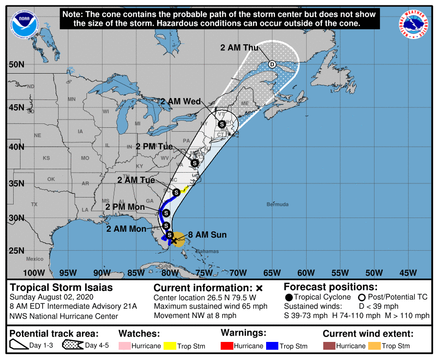
Dare County ordering no additional protective measures; evacuation for Hatteras Island remains in effect
Published 10:14 am Sunday, August 2, 2020

- NOAA image
|
Getting your Trinity Audio player ready...
|
A Sunday morning bulletin from the Dare County Emergency Management Joint Information Center stated that local officials met Sunday morning to receive an update from the National Weather Service.
“Based on the current forecast, no additional protective measures are being implemented at this time,” stated the bulletin. “While an evacuation order is not anticipated, it is imperative for everyone to keep their guard up and pay close attention to updated weather forecasts from the National Weather Service because the Outer Banks will experience impacts.”
Dare County remains under a State of Emergency with mandatory evacuation orders in effect for Hatteras Island (Hurricane Evacuation Zone A), including the villages of Rodanthe, Waves, Salvo, Avon, Buxton, Frisco and Hatteras Village. These orders will remain in place until after the storm passes due to the vulnerability of Highway 12 and because it is the only road that provides access to and from the island. Some vulnerable spots along Highway 12 on Hatteras Island are already experiencing minor ocean overwash during periods of high tide.
As the storm tracks west of the Outer Banks and winds increase late Monday, storm surge inundation is anticipated to produce ocean overwash and soundside flooding of 1 to 2 feet above normally dry ground, and up to 3 feet in some areas.
Soundside Flooding
Water levels along the sound are already high in many places, particularly from Manteo to Kitty Hawk. Expect soundside flooding in low lying areas at spots that are impacted by southerly winds. It is advised those in the area make preparations for up to 3 feet of water above the ground in these areas. Real time soundside water levels can be observed at https://fiman.nc.gov/.
Ocean overwash
Ocean overwash is likely along Highway 12 on Hatteras Island and driving conditions are anticipated to become hazardous in some areas. Conditions may impact the ability of law enforcement, fire and emergency medical service personnel to reach those needing emergency assistance in a timely manner. Overwash will also likely flood normally dry areas where the dune system is vulnerable, which could lead to damage to parked vehicles and other property.
There is a high risk of rip currents and hazardous ocean conditions at all beaches south of Currituck over the next few days and conditions are dangerous for even the most experienced swimmers. Beachgoers are advised to stay out of the water and obey red flag warnings on the northern beaches. As part of the current state of emergency declaration that is in place, restrictions on ocean swimming remain in effect for Hatteras Island.
There is an increased threat for tornadoes in the area beginning late Monday and into Tuesday. “Again, pay close attention to weather forecasts. Keep your cell phone charged and make sure it is set to receive emergency alerts. It is also a good idea to listen to NOAA Weather Radio to keep informed,” stated the bulletin.
For updated information from Dare County Emergency Management and the Towns of Duck, Southern Shores, Kitty Hawk, Kill Devil Hills, Nags Head Manteo and the National Park Service, visit darenc.com/isaias.
For preparedness tips and information on hurricane evacuation zones, visit www.readync.org.
READ ABOUT MORE NEWS AND EVENTS HERE.


